Accurate, site-specific channel information is crucial for optimizing next-generation wireless networks. Localized statistical channel modeling (LSCM) reconstructs the channel multipath angular power spectrum (APS) from RSRP measurements, but cannot predict APS at locations without measurements. We present PC-TGS, the first framework to extrapolate APS to unmeasured outdoor grids by integrating sparse radio measurements with dense LiDAR geometry. PC-TGS represents environmental scatterers as anisotropic 3D Gaussians, initialized and refined through a relaxed-mean reparameterization of the raw point cloud. A tangent-plane projection maps each Gaussian into the local angular domain, while a depth-aware electromagnetic splatting process aggregates their contributions. We derive a closed-form Gaussian-weighted average (GWA) for APS bin integration with a provable error bound. Evaluations on a city-scale dataset (5M LiDAR points, 6,310 RSRP samples) demonstrate that PC-TGS significantly outperforms state-of-the-art baselines in both accuracy and inference speed.
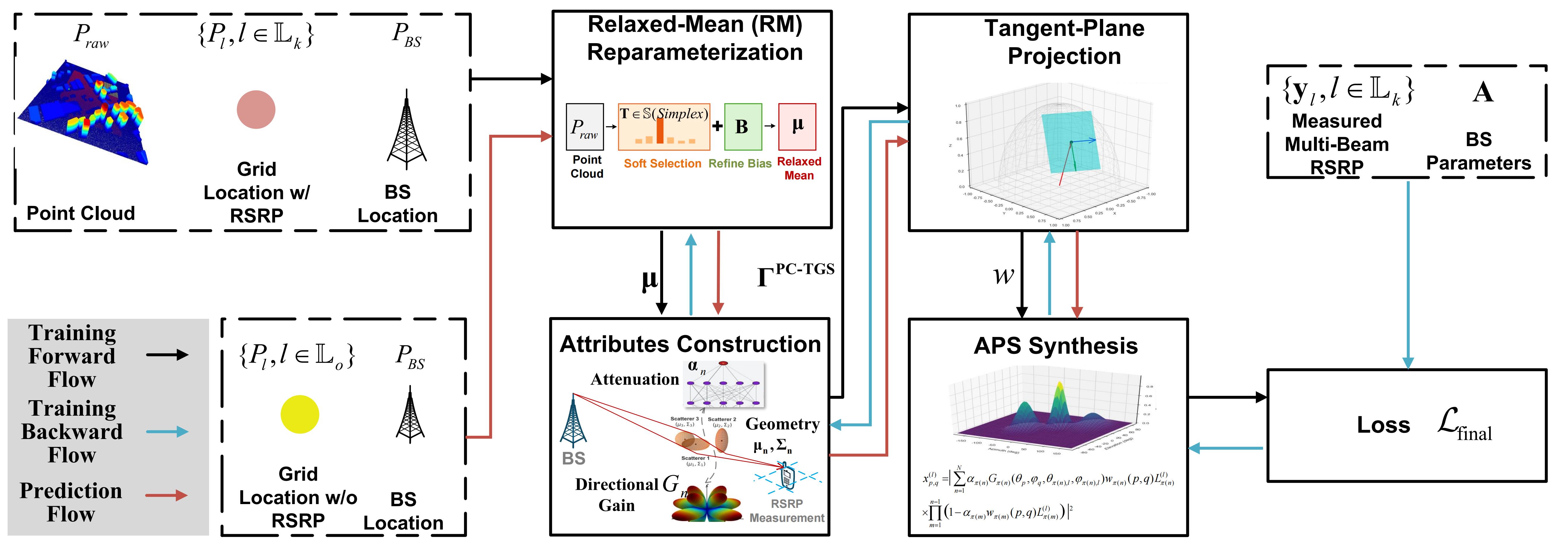
Relaxed-Mean Reparameterization. A learnable selection matrix T softly selects N virtual scatterers from R raw LiDAR points, with a bias term for denoising. This bridges noisy, dense point clouds with compact, physically meaningful scatterer proxies.
Tangent-Plane Projection. Unlike camera-based 3DGS, we project each 3D Gaussian onto the tangent plane of the unit sphere at each angular bin (θ, φ), mapping environmental geometry into the antenna angular domain.
GWA-Based APS Integration. We replace the intractable bin integral with a moment-matched Gaussian window, yielding a closed-form weight formula with a provable O(Δθ³ + Δφ³) error bound.
Electromagnetic Splatting. Depth-sorted alpha compositing accumulates complex multipath contributions, reinterpreting visual rendering as multipath superposition. Each scatterer learns anisotropic covariance, complex spherical harmonic coefficients (degree 0–4), and an MLP-predicted attenuation & phase.
City A dataset: 5M LiDAR points, 6,310 grids, 32 RSRP beams per grid
| Method | Type | ST-1 (dB) ↓ | ST-2 (dB) ↓ | ST-3 (dB) ↓ | Inf. Time (ms) |
|---|---|---|---|---|---|
| PC-TGS (ours) | Offline | 5.57 | 7.45 | 7.57 | 73.6 |
| PC-TGS w/o RFT | Offline | 5.43 | 8.23 | 8.62 | 73.5 |
| MM-LSCM | Offline | 5.76 | 9.12 | 9.94 | 379 |
| SM-LSCM | Offline | 5.89 | 10.02 | 11.14 | 99 |
| RadioUNet | Offline | — | 10.31 | — | 2.1 |
| WNOMP | Online | 6.12 | 13.35 | 15.07 | 1.5 / 8,032 |
| TMSBL | Online | 6.03 | 11.69 | 11.77 | 134 / 9,743 |
| Ray Tracing | Online | — | 14.37 | 16.77 | 8,100 |
ST-1: rotated RSRP @ measured grids | ST-2: RSRP @ unmeasured grids | ST-3: rotated RSRP @ unmeasured grids | MAE in dB (lower is better)
At 50% measurement density, PC-TGS (9.25 dB) still outperforms RadioUNet trained at full density (10.31 dB).
We proposed point-cloud-assisted tangent Gaussian splatting (PC-TGS), a physically grounded framework that extrapolates the channel APS to grids where no signal measurements are available. PC-TGS fuses LiDAR geometry and RSRP data in an end-to-end differentiable pipeline integrating relaxed-mean scatterer parameterization, tangent-plane projection, and depth-aware electromagnetic synthesis, made possible by a novel GWA-based closed-form bin integration. Experiments on a city-scale dataset show clear accuracy gains over existing single- and multi-modal baselines. PC-TGS enables geometry-aware, data-efficient channel prediction for large-scale wireless digital twins.
@article{xue2026point,
title={Point-Cloud-Assistant Localized Statistical Channel Prediction
by Tangent Gaussian Splatting},
author={Xue, Ye and Wang, Yiheng and Shao, Xinhua and
Yan, Qi and Zhang, Shutao and Chang, Tsung-Hui},
journal={IEEE Transactions on Wireless Communications},
volume={25},
pages={17816--17830},
year={2026},
publisher={IEEE},
doi={10.1109/TWC.2026.3696997}
}